Brief by Shorts91 Newsdesk / 08:43am on 29 Aug 2026,Saturday International
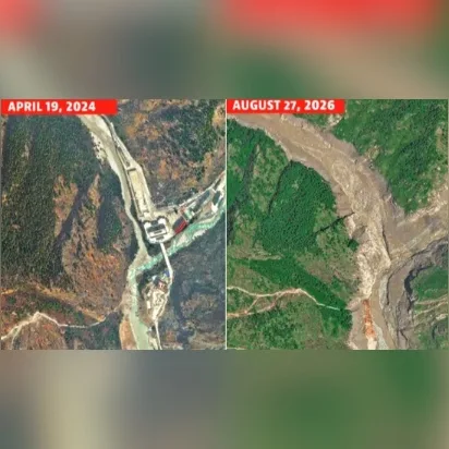
Satellite imagery has revealed the devastating impact of flash floods along the Nepal-China border. Images comparing the Gyirong Port–Rasuwagadhi border crossing before and after the disaster show that almost the entire border complex, including buildings, roads and a bridge, was swept away within a day. The disaster struck after a massive surge of water and debris devastated the Himalayan region. Rescue operations entered their fourth day on August 29, with at least 2,478 people still untraced. The images provide a stark visual record of the destruction and highlight the enormous challenge facing rescue teams and authorities. (PC: AFP)